Tom’s Tech Tools for Laser Mapping
All the Data You Need in One Drive
As engineers, we’re the first to admit that we’re fascinated by technology. We love to understand how things work and find new ways to make them work better, faster, easier, more cost-effectively, or all the above. E.L. Robinson (ELR) head of geomatic surveying, Tom Rayburn, frequently uses technology tools like laser mapping, which helps us collect thousands of data points in each scanning drive.
Surveying for Civil Engineering
In civil engineering, surveying is a component of many kinds of projects, and a critical part of geomatics, or the mathematics of the earth. In an engineering survey, we inspect an area to determine its condition or state and delineate details and dimensions for the intended use. From highway design, site development, stream restoration projects, infrastructure design, and even hydro-surveying, we depend on our surveyors and their tools.
Laser Mapping Technology for Surveying
Surveying has been supporting civil engineering for millennia - literally. Traditional land surveying used tools like compasses, chains, rods, and theodolites (a precision instrument that measures angles in the horizontal and vertical planes). Surveyors created accurate maps by manually recording observations and employing mathematical calculations.
We’ve all done manual land mapping, and sometimes we still do, but now we have the latest mobile scanning technology for laser mapping, which is much more efficient. It’s not only faster, but it also reduces the need for return surveying. All of that saves money in addition to time. But wait, there’s more. This technology allows us to simplify the logistics of the surveying process. On highway survey projects, we can avoid lane shift traffic control, which creates traffic flow and safety challenges.
Rayburn says. “I would say that laser mapping through mobile scanning saves us about half the time on certain projects. Maybe more considering all aspects we are able to address.”
Mobile Laser Scanning Technology
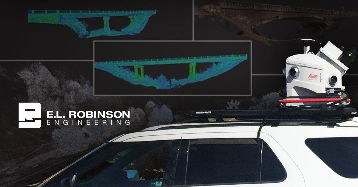
As early adopters of 3D Scanning, Rayburn and ELR have been using this game-changing technology for laser mapping consistently for almost a decade, and it just keeps getting better. The mobile laser scanning technology from Leica Geosystems enables us to conduct data processing in just one drive-through, create 2D plans, and do our 3D modeling in-house.
3D Laser Scanners can collect over 1 million points per second and can go places that often take hours or may be impossible to safely send survey technicians.
With so many service offerings, we have nearly endless opportunities to apply mobile laser mapping. It applies to streetscapes, contouring, terrain modeling, landscape architecture, retrofitting, process piping, volumetric surveys, and more.
ELR bought our first laser scanner, a Riegl Z360i, in 2005, and now in 2023, we’ve employed multiple 3D laser scanners. We have multiple surveyors trained to use mobile scanning for 3D mapping across our offices in West Virginia, Ohio, and Kentucky.
Sample Laser Mapping Enabled Surveying Projects
We could talk about our cool technology tools all day long, especially when Tom and his employees are in the room. Let us know if you want to have that conversation. In the meantime, below are a couple of good examples to help illustrate the value of mobile scanning.
Statewide West Virginia Bridge and Roadway Mobile Scanning
Working with the West Virginia Department of Highways (WVDOH), ELR provides accurate and efficient laser mapping with our Leica Pegasus: Two Mobile Sensor Platform. This innovative mobile sensor platform enables us to capture point cloud and image data with survey-grade accuracy at a fraction of the time for conventional surveying. For mapping interstate highways and expressways, ELR works with law enforcement to provide a “moving work zone.” A law enforcement escort creates a “rolling roadblock” behind our mobile scanner ensuring that we can collect the data cleanly, safely, and efficiently at highway speeds of up to 55 miles per hour with minimal impacts to traffic flow.
The resulting data point clouds work in most modern CAD and GIS software (AutoCAD, MicroStation, ArcGIS, etc.) and can also be used for 3D modeling, DTM, and mapping creation as well as GIS/Asset Management applications. ELR’s years of processing point cloud data have allowed for the refining of workflows to maximize feature extraction efficiency to quickly meet and exceed project requirements.
Leica Geosystems Case Study Article
In Leica’s Case Study, “70 Miles of highway-mapping to full engineering design in 99 days,” featuring ELR, author Penny Boviatsou covered extensive details of a demanding 70-mile highway laser mapping project we completed for WVDOH in only 99 days. This transportation project had no existing as-built map. To meet the timeline, the data had to be collected by mobile mapping, including:
- Mapping a 70-mile, two-lane highway
- Static scanning of 12 bridges
- Curve widening and slide repair
- Creation of the Digital Terrain Model (DTM)
- Extraction of topographic features, such as edge of pavement, striping, signage and utility poles
- Culvert survey and inspection of more than 500 culverts and pipes
- Setting permanent control for bridges.
- Keeping pace with demanding deadlines
More Information
Want to see the laser mapping technology in action or discuss a surveying project? Contact us to speak with Tom Rayburn or visit our Surveying and Technology Services page to learn more.